

Utility to convert Shuttle Radar Topography Mission (SRTM) DEMs into LandSerf format.
SRTM DEMs at a 3 arc-second resolution (~90m at the equator) are freely available for most of the globe. Additionally, 1 arc second (~30m at the equator) SRTM DEMs are available in various formats for the continental United States.
SRTM data are often distributed in '.hgt' format as described in the SRTM documentation. Data for the United States are also distributed in other raster formats from the USGS seamless data server. HGT format data for Europe, Asia, North and South America can be found at http://edcsgs9.cr.usgs.gov/pub/data/srtm/
To install the SRTM converter download the appropriate file below and uncompress into your LandSerf installation folder
(e.g. c:\landserf200). This should create a sub-folder called addons with several files including
SRTMConvert.bat and srtmConvert.sh.
To run SRTMConvert, open a command prompt in Windows (Start menu->Run...->cmd)
and then change to the directory in which the converter is installed (e.g. cd \landserf200\addons)
and type SRTMConvert srtmFileName [removeVoids] where srtmFileName
is the SRTM '.hgt' file to convert. If you wish to remove voids (missing data) from the surface, you can optionally
include the removeVoids parameter. This will interpolate any missing values based on known neighbouring
cell values.
SRTMConvert c:\data\surface.hgt (Windows)
or
SRTMConvert c:\data\surface.hgt removeVoids (Windows)
./srtmConvert.sh ~/data/surface.hgt (Unix)
or
./srtmConvert.sh ~/data/surface.hgt removeVoids(Unix)
Running the converter will create a new file called surface.srf in the same directory as the .hgt file. Note that
the name of the file is important since this contains information about the location of the DEM. For example,
N55W003.hgt refers to a DEM with an origin at 55 degrees North, and 3 degrees West.
You will probably need to reproject the converted surfaces into UTM or OSGB coordinate systems in order to perform useful analysis within LandSerf. When reprojecting within LandSerf, make sure the interpolate to new resolution box is selected. Note that the unprojected north-south resolution of the original data is fixed (e.g. about 92m for the 3 arc-second data), but the east-west resolution dependent on latitude (e.g. varying from about 90-40m for the 3 arc-second data).
SRTM .hgt data are provided as tiles. To combine more than one tile into a single LandSerf raster, convert each one
separately, load at least two of them into LandSerf making sure one is selected as the primary raster, the other as
secondary raster and then select Edit->Combine Rasters.... Make sure you select the Union
option for combination. The new combined raster from this process can then be combined with further converted tiles.
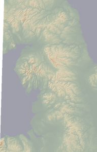
It is recommended that you project the data onto UTM/OSGB after combining tiles. The figure above shows 9 tiles
of Northern England combined into a single DEM.