Accuracy of Elevation Measurement Using GPS
The Eastway cycle circuit, near Stratford, E. Longon, is a 1 mile loop used for training and racing. It is an undulating course containing approximately 30m of elevation gain per lap. The sky view is good throughout and so provides a useful testbed for calibrating GPS tracks and elevation measurement.
As an experiment to assess the accuracy of elevation measurement from a GPS with barometric altimeter, I used a Garmin Edge 305 GPS receiver with built-in barometric altimeter to record the elevation around 100 laps of the circuit. This took place over 6 hours from 10:00-16:00 on Saturday 11th November. This period concided with a retreating weather front which should result in a slowly increasing pressure during the day.
Recording was started immediately after a 'cold-start' of the GPS without manual calibration of the barometric altimeter. Elevation was recorded by the device at a planimetic interval of between 50-100m depending on speed and changes in direction. Distance for the 100 laps was measured as 161.6km, approximately 600m over distance (0.4% error).
The graph below shows the elevation profile produced by the GPS.
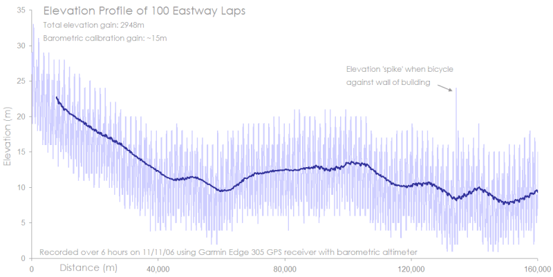
- The light blue profile represents all elevation values, one large peak per lap. The dark blue line represents moving average over five laps.
- Total climbing measured by the GPS was 2948m
- There is a barometric drift evident in the moving average. The total variation in baromatric drift is ~13m, resulting in this instance in a spurious elevation gain of ~15m.
- There is a single elevation 'spike' produced when the bicycle was stopped and leaning against a building resulting in a partial sky view. With barometric correction this resulted in ~5m of spurious elevation gain. Without barometric correction this is likely to have been much greater.
To exmine in more detail how elevation varies over a single lap, the first 10 laps (during which time the barometric drift was strongest)
are shown below.
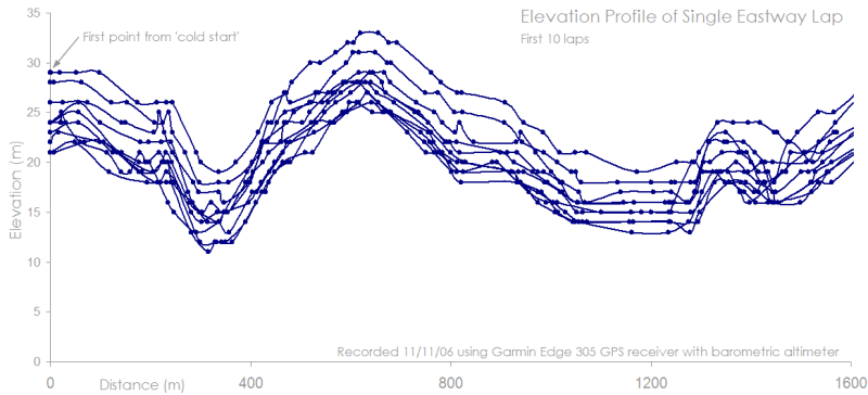
- Blue dots represent the recorded elevation, lines are interpolated with smoothing.
- Spurious elevation peaks are no more than 1m per lap. Average spurious peaks are ~0.5m per lap.
- Average recorded height gain per lap is 29.5m. The quoted height gain for the Eastway track is "apprimately 20m per lap" This represents a major discrepency. If the GPS is in error, then this would appear to be a systematic error in the way it records elevation. This seems unlikely given the degree of discrepency.
Conclusions
- While barometric drift can cause large (15-20m) errors in aboslute elevation, the fact that it is correlated over time means that this has very little proprotional effect over common Audax distances.
- The Standard Deviation (average variation) in elevation for each lap was ~2.5m, representing an average error rate of ~10%. While high, this test represents the worst-case terrain, containing many undulations and direction changes.
- On the Edge 305 at least, there is no measureable 'spike' in elevation caused by a cold start of the device. Assuming no manual calibration of the barometer is made, it should be possible to record elevation as soon as the GPS is turned on.
- The accuracy of elevation recording is dependent on good sky views from the GPS. Routes that travel though wooded areas or steep sided valleys are likey to contain more spurious spikes than indicated by this experiment. To assess elevation accurately, it is necessary to graph the profile in order to identify these spikes.
- The other source of discrepency between various methods of height estimation is the frequency with which elevation is measured on the ground. Large gaps between recordings will smooth a terrain, small gaps will record every single undulation. This effect is further dependent on the complexity of terrain. The experiment above represents about as complex a terrain as would be possible to get on a typical Audax. Sharp changes in direction and constant undulating changes in elevation for 160km. Most real routes should result in more consistent measures of elevation than those shown in this experiment.